Total ascent, 391m (1283ft).
Friday, 2nd August.
Total distance over 11 days = 195.9 miles.
Total ascent over 11 days = 7496m (24,593ft)
I was expecting a hot finale rather than a grand one, and today didn't disappoint. Neither did the fajitas at The Cottage Inn last night, my room at the lovely Pont-y-Clerc Farm B&B, nor this morning's breakfast of porridge with homemade honey. The forecast was for hot and clear weather, much closer to the dreaded Day One temperatures than yesterday's. But this time I was ready; fitter, used to carrying the rucksack and carrying 4 litres of water.
The last 5 miles were brutal though.
My predictions for today's walk were:
Miles 1 to 8 - fun.
Miles 9 to 14 - not fun.
Miles 15 to 20 - a little bit fun and a little bit not fun (in 'Year 4 language').
The reality was:
Mile 1 - not fun.
Mile 1 again - not fun.
Miles 2 to 8 - fun.
Miles 9 to 11 - not fun.
Miles 12 to 14 - better than the not fun I expected.
Mile 15 - fun.
Miles 16 to 20 - the aforementioned 'BRUTAL'.
A little more detail is required, I think.
Mile 1 involved me finding a sneaky path from my B&B to the Heart of Wales Trail, getting stuck in brambles again and turning back, finding a second sneaky path and having to turn back again, finding a third sneaky path which ended deep in a wood at a tarpaulin shelter with voices inside (so I ran away) and finally returning to sneaky path 1 (outside the gate of the B&B!), putting my waterproofs on despite the heat and attacking the brambles. This end part was 'Mile 1 again', after which I stopped at Pantyffynnon station (very nice), removed my waterproofs, recomposed myself and rejoined the HoWLT. A terrible start.
The next 7 miles were superb, up and along a long ridge before descending into Pontarddulais where a lifesaving coffee shop was waiting (note how I skim over the good bits!). I ordered a flat white and carrot cake, and when the lady brought it over she made a comment and I said it. I had no intention of saying it, it just came out. She said, "It looks quite hot outside." I replied with, "It is. I could do with a bit more breeze, truth be told." I was going to apologise, but just looked down instead. If I say, "What's occurring?" between now and tomorrow morning I may have to remain here forever.
Miles 9 to 11 looked grim on the map and they were on the ground, through ceaseless baking fields of various crops, the only respite being the path underneath the M4 where I hid with a flock of sheep who were too tired to even bother running away. I was on the main HoWLT for this stretch rather than an alternative in the book because the tide was out, and by far the best part was the tidal section, walking over grass that had been underwater just a few hours earlier. Actually I'd mis-calibrated my altimeter by about 10 metres this morning, which meant that for almost all of the last 12 miles it told me I was beneath sea level, which was slightly unnerving.
Miles 12 to 14 were better as there were tracks to follow rather than having to plough my own furrow, and Mile 15 was fun because I finally reached the coast, crossed the Llwchwr Estuary on the A484 road bridge and set off towards Llanelli on the Wales Coast Path, with great views across to the Gower Peninsula.
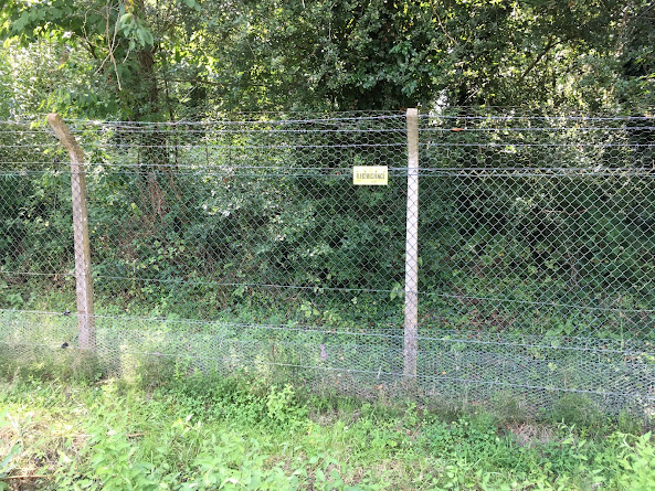
Then a sea wall appeared on my left. It was about a metre above my head and ensured that I saw nothing at all of the coast for the next 3 miles. When it wasn't there it was replaced by the 8 foot, barbed wire topped, ELECTRIC boundary fence of the much celebrated National Wetlands Centre. I mean, how many people are really going to break into the National Wetlands Centre? And if they did would it actually matter?
So with either a sea wall or a scary ELECTRIC fence on my left, what was on the right? Well firstly we had an enormous caravan site, then 8 foot trees to mirror the fence, then a golf course. It was only at the end of the golf course that the sea wall finally vanished, the views returned and I waited for the breeze. There was no breeze.
Which left 2 more oven-baked miles to the finish. At this point I recalled that the guide book lists this section as the busiest of the entire route. Not today it wasn't; I was one of the few idiots out and about on this tarmac sun trap of a cycle path. The temperature remained over 30°C for the entire last hour and a quarter.
So I walked straight past my (again lovely) B&B, Queen Victoria Rooms, to find coffee and cake, got cleaned up and I'm now in the middle of Llanelli (I think, if it's got a middle) eating Italian pizza and tiramisu (not together) and drinking Spanish San Miguel. It's just too hot for British beer and food!
Finally, I still haven't officially finished even though I've walked beyond Llanelli Station. I'll be there to celebrate and catch my train in the morning and the payoff is that I'll be heading back to Shrewsbury on the Heart of Wales Line, clocking every station that I've visited along the way. It's been a fabulous walk in bizarre weather, and despite today's ending for next year I think I can feel a coastal walk coming on.


